Call : 08045803129
 Send Inquiry
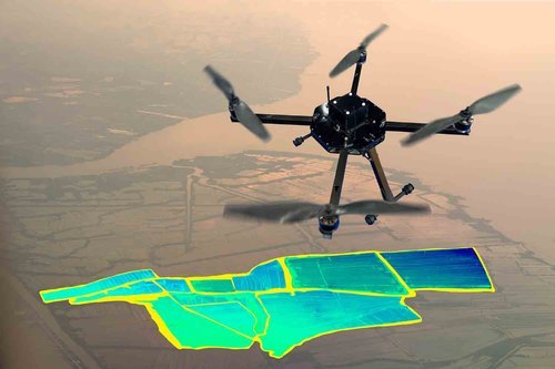
In the realm of modern technology, drones have emerged as invaluable tools in various industries, transforming conventional practices and revolutionizing the way tasks are accomplished. Among their many applications, mapping and surveying stand out as areas where drones have made significant strides, offering unparalleled precision, efficiency, and cost-effectiveness. At Drones Tech Lab, we are proud to introduce cutting-edge Mapping and Surveying Drones, equipped with state-of-the-art features to meet the diverse needs of professionals across different sectors.
Specifications
- Flight Time Up to 35 minutes per battery charge
- Maximum Range Up to 5 kilometers
- Payload Capacity Camera Module
- GPS/GNSS Accuracy Navigation system GNSS
- Camera Resolution 50 megapixels up to 4k resolution
- LiDAR Resolution Sub-centimeter accuracy
- Flight Control SoftwareOperational Authorisation Sensor
- Fail Safe Features Return To Home Function while signal lost, battery about to die and after complete the mission
- Portability Compact and lightweight design for easy transport and deployment
In conclusion, our Mapping and Surveying Drones represent a paradigm shift in the way professionals approach mapping and surveying tasks. With their unmatched precision, efficiency, versatility, and ease of use, these drones empower users to accomplish their projects with greater accuracy and speed than ever before. Whether you're a land surveyor, an agricultural engineer, an urban planner, or an environmental scientist, our drones are the ideal companions for all your mapping and surveying needs. Discover the future of surveying technology with Drones Tech Lab's Mapping and Surveying Drones.

Price:
|
 |
RCHOBBYTECH SOLUTIONS PRIVATE LIMITED
All Rights Reserved.(Terms of Use) Developed and Managed by Infocom Network Private Limited. |
 English
 Spanish
 French
 German
 Italian
 Chinese (Simplified)
 Japanese
 Korean
 Arabic
 Portuguese